Wednesday, April 25, 2012

To sum up Hawaii....

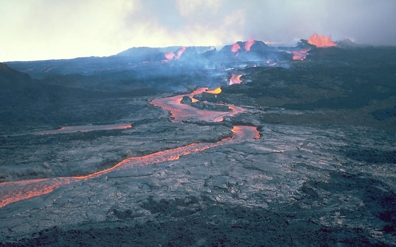
Hawaii was born from the Mauna Loa and Kilauea volcanos.  Recall that the volcanoes are classified as shield because of the dome shape and gradual slope. Lava does not only escape from the top but also all around cracks or fissures. This type of volcano is know for the extensive lava tubes that carry lava far from the volcano itself. 

   
Mauna Loa and Kilaeua are the most prominant volcanoes on the island of Hawaii


The Thurston lava tube in Hawaii once carried lava far from the volcanoes. The lava has now run its course and people can walk through the tube.


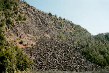
The island of Hawaii is constantly changing due to weathering and mass wasting.  Rock slides and rock slumps are common.  Recall that rock slumps are curved lines of failure and rock slides are straight lines of failure. 

                          
Visual aid to compare rock slump and rock slide. 

     
Rock slump on the big island (On top)             Evidence of rock slide, notice angle of cliffs
'
The ocean around the island also constantly beats on the coastlines, reshaping and erroding it everyday.  As the water from the waves bring sediment, or sand, on to the beach, it also carries some sediment back into the ocean.  This is a process called "swash and backwash". 

The swash indicates the ocean coming up to the beach and backwash indicates the water retreating.  Notice how swash comes up at an angle and backwash goes straight down.

Swash and backwash in real life.


As the island continues to grow from the lava flows the ocean slowly errodes it away.  This means that over time Hawaii will change drastically.

Hawaii in 10 years...

In ten years I predict that Hawaii will not look too different than it does today.  Ten years in geographical terms is not long at all.  According to wikipedia the island grows about 3.5 meters per day from the lava flows meeting the ocean waves and cooling.  That is about ten feet per day.  This means that in 10 years it will have grown nearly 36,500 feet.

Lava meeting the ocean.  The black areas represent new land that has been formed.


Another view of new land created from cooled lava.

It is important to remember that Hawaii is moving over a hot spot on Earth.  According to the Oxford dictionary a hot spot is "Also known as a plume, this is an area of localized swelling and cracking of the earth's crust due to an upward welling of magma."  The plate where Hawaii is located moves over the hotspot very slowly.  In the future the big island will no longer be over the it however more islands are likely to form.


Magma comes up from Earths mantle in a hotspot and a volcano is formed.  All the Hawaiin islands were formed from the hotspot.

Hawaii in 50 years.....

In fifty years the island of Hawaii will be slightly closer to Japan.  Accorrding to researchers from soest.edu the Pacific plate (where Hawaii is located) is moving about 7cm a year.  This means that in fifty years the island will move about 350 cm from its current location. 


This picture shows which direction the Pacific plate is moving for reference.

In fifty years there will be more evidence of mass wasting as Hawaii grows older and weathering occurs.  The cliffs may become steeper as rock slides continue and the beaches will become more linear as the ocean is trying to reach equilibrium with the land. 


Cliffs on the big island, linear failure plane shows evidence of rock slide


The ocean errodes the rock so that eventually the beach will look like......


Notice how land and ocean run almost parrallel to eachother, reaching equilibrium.


Hawaii in 1000 years....

In 1000 years Hawaii should grow about 3,650,000 feet and move towards Japan about 7,000 cm with the statistics.  However it is also moving away from the hot spot and there is another island being born off the coast.  This new island is Loi'hi and is 22 miles away from Hawaii.  It is 10,000 feet above the ocean floor and continues to build up as the plate moves over the hot spot.  Accorrding to wikipedia it is expected to emerge from the ocean in about 10,000 years.
The island of Hawaii, showing Loihi's position southeast of the main landmass
Loi'hi is close to the big island and feeds off the same hotspot.


This pictures shows that currently the hot spot is feeding both the volcanoes in Hawaii and the new island Loi'hi.

In 1000 years the big island of Hawaii will be cut off from the hot spot as the plate moves toward Japan and therefore will stop growing.  Both Mauna Loa and Kilauea will become dormant, or no longer be active volcanoes because there will be no lava or magma to fuel it.  Hawaii is the biggest island in the chain, but as errosion and weathering take over it may become smaller and resemble the older islands.


Hawaii is clearly the biggest island compared to the older ones.


Final sights of Hawaii.....


Valley on the island


Beautiful beach


Sunset on the island

Thursday, April 5, 2012

 Clouds....Hawaiian Style
The big island of Hawaii is a prime location for different cloud types.  The land mass of Hawaii is completely surrounded by water that can be converted into moisture droplets.  In order to for a cloud to form all that is needed is cloud condensation nuclei, which are tiny particles of water, dirt, particles, or anything that water molecules can bind to (Groom, 2012).  When they collide and come together they can become big enough to be raindrops that eventually fall from a cloud.  A cloud's primary goal is to have some sort of precipitation, whether it be snow, rain, etc.. (Allen, 2012).  Below are just a few types of clouds that can be seen over Hawaii.


http://travel-destination-hawaii.blogspot.com/2008/11/clouds-over-hawaii.html

The picture above shows beautiful cumulus clouds.  The cumulus clouds are defined by their "lumpy or heaped" characteristics.  They almost look like cotton balls in the sky.  Cumulus clouds are considered to be low level to mid level clouds.  This means that they form closer to the earths surface.  In the picture it is clear that some clouds have a flat bottom.  This indicates the dew point.  The dew point is where precipitaion could start if the conditions are right.

Cool Clouds
http://www.digitalapoptosis.com/category/Hawaii/

The clouds in the picture above are classified as cirrus clouds.  These are high level clouds that form high above the earths surface.  They are distinguished by their wispy features that almost look hair-like.  On the bottom right there also appears to be a cumulus cloud.  It is important to remember that it is not unusual to see more than one cloud type in the sky at a time.  This is actually very common. 


http://scijinks.jpl.nasa.gov/clouds-gallery

The above picture shows the stratus clouds, or clouds that are defined by their layers and appear to be featureless.  These are the clouds that look like a blanket over the sky and have no distinct features.  Like cumulus clouds, these are low-level and form close to the ground compared to the cirrus. 

The above pictures depict the very basic cloud types that are encountered in Hawaii.  It is important to remember that clouds can change types quickly and it is not uncommon to see more than one cloud type in the sky.  For more detailed information about types of clouds reference the picture below:


http://clasfaculty.ucdenver.edu/callen/1202/Climate/Moisture/cloudstypesdiagram.jpg

Using the chart above see if you can identify the clouds in the photos below...


Wednesday, February 29, 2012

Mass Wasting on the Big Island

Mass wasting, or the downward movement of mass due to gravity, streams, mudslides, etc, can be seen throughout the big island.  Although there are numerous mass wasting events that can occur all over the landscape, rock falls and rock slides are common due to the fact that steep slopes and cliffs are abundant all over Hawai'i.

Major Rock Slide Just North of Pali Kaholo


http://0.tqn.com/d/gohawaii/1/0/7/G/4/hula_kai_013.jpg

This rock slide occured just north of Pali Kaholo on the big island.  It is classified as a rotational slump slide because of the curved plane of failure.  This means that rather than rock falling down a flat plane, the ground literally "slumped" down.  Think of a student slumping in a boring class after 10 minutes. A rotational slump differs from a translational slide due to the fact that the end result will look like a curve instead of a straight line that a translational slide will produce.  Translational slides occur when there is a flat plane line of failure and debris literally SLIDES down a slope. In order to show the difference between a rotational slump and translational slide pictures are provided below. 


http://clasfaculty.ucdenver.edu/callen/1202/Battle/Destroy/MassWasting/SlumpDiagramX.jpg (Slump)
http://clasfaculty.ucdenver.edu/callen/1202/Battle/Destroy/MassWasting/rockslidebasicAfter.GIF (Slide)

More rock slides around the big island...

http://hvo.wr.usgs.gov/kilauea/update/archive/2006/Oct/IMG_3056.jpg

(The picture above shows a translational rock slide because of the flat plane that the rocks slipped down into the ocean)


Another mass wasting event that is common on the big island are rock falls. A rock fall occurs when there is detachment from a steep slope from events like erosion.  Once the rock (or rocks) is completely detached from a side of the slope it falls due to gravity. The rocks that fall can range in sizes from very small pebbles to very large boulders. Rock fall produces talus, or the pile of rock found at the bottom.  Once the talus accumulates it forms talus cones.  The picture below shows a talus cone at the base of the Kilauea Caldera.  The cone shape of the talus is very clear.

http://community.middlebury.edu/~jmunroe/hawaii_03_1_files/image002.jpg

On the big island rock falls are common around waterfalls.  Waterfalls create the perfect atmosphere for rock falls with very steep cliffs and water flow that erodes away at the rock underneath it. People who visit the waterfalls need to be careful when there is evidence of rock fall and not get too close to avoid the risk of being hit.

http://www.fmschmitt.com/travels/Hawaii/Oahu-Manoa-Falls/20070111_hawaii_oahu_manoa_falls_trail_071.JPG


http://farm3.static.flickr.com/2279/2335828796_531894ee03.

Tuesday, February 7, 2012

If there is one thing the Big Island of Hawai'i is famous for, it is the volcanoes that have created it.  The Big Island has numerous volcanoes, however I will focus on Mauna Loa and Kilauea.


Image By: (http://www.google.com/miami.edu)

Due to their large, gentle slopes Mauna Loa and Kilauea compose much of the island.  The gentle slopes are formed because the lava flow is very fluid, or has low viscosity, and can spread out for miles and miles around the volcano.  The lava does not build up on itself due to the fact that it flows at a low angle.  The lava does not only come out of the top of the volcano, but can also can escape through cracks or fissures  all around the fractured volcano (Casey Allen, 2012).  Mauna Loa and Kilaeua are shield volcanos, which makes them the least violent and dangerous type of volcano.  They also fall under the category of mafic volcanoes, which means that they do not erupt or explode like other volcanoes do.


This is a photo of Mauna Loa taken from Kilauea ( http://dan-spencer.blogspot.com/2011/12/hawaii-thanksgiving-with-pele-at.html)

Both Mauna Loa and Kilauea are active volcanos, in fact Mauna Loa is the largest active volcano in the world! (http://hvo.wr.usgs.gov/maunaloa/).  Being shield vocanoes, their eruptions are not as dramatic as other types of volcanoes eruptions can be.  They do not produce large amounts of ash (tephra) nor do they produce volcanic bombs.  Volcanic bombs are molten rock that is ejected during an eruption and cools into a solid object before it hits the ground (http://en.wikipedia.org/wiki/Volcanic_bomb).  Shield volcanoes can produce spatter (molten rock that can be ejected from a volcano vertically) when erupting which can can be dangerous.

File:Aa channel flow from Mauna Loa.jpg
Lava flow and spatter in background.  Image by: http://en.wikipedia.org/wiki/File:Aa_channel_flow_from_Mauna_Loa.jpg


http://www.youtube.com/watch?v=zLmjaFu3tus

(Follow the above link for footage of Mauna Loa erupting in the 1940s)

Shield volcanoes are known for their extensive lava tubes which are formed when the outside of a flow cools first and the inside keeps moving, which leaves a cave behind once the lava has run its course. The lava tubes are essential when forming a massive shield volcano because they allow the lava inside to flow without much cooling.  Therefore the lava can spread for miles away from the center of the volcano (http://volcanoes.usgs.gov/images/pglossary/ShieldVolcano.php). People that visit the Big Island can go and explore massive lava tubes in Hawaii Volcanoes National Park that were formed 500 years ago when the lava stopped flowing through the tubes and flowed down hill (http://www.gohawaii.com/big-island/regions-neighborhoods/kau/nahuku-thurston-lava-tube).


Inside of the Thurston Lava Tubes in Hawaii Volcanoes National Park. Image by: http://www.adventure-caves-usa.com/images/cave_types_lava_caves.jpg


Wednesday, January 18, 2012

Hello! My name is Taylor Bakemeyer and I have chosen the Big Island of Hawaii as my location for this term.


Although my location is not the most creative I find the Big Island to be a fascinating geographical site.  I had the chance to visit Hawaii almost six years ago and was able to see the Mauna Loa and Kilauea volcanoes that are still very active on the island.  It amazed me to see how the geography of the area allows the island to grow bigger literally everyday.  On top of that the physical geography of Hawaii is very diverse and can range from tropical beaches to dry deserts where the lava has cooled. For these reasons the Big Island of Hawaii is my location of choice and I cannot wait to learn more about the island I visited so many years ago.


(Image from: http://www.travelersjoy.com/images/planning/destinations/hbi_1.jpg )